Stonemasonry in the Říčany Region – Lesní potok, Part 3

The Lesní potok basin is linked to stonemasonry only by its geological bedrock – the Říčany granite. In the northern part of the catchment we can find a fine-grained variety of the rock – the so-called Jevany granite. Just as most granitoid rocks, the Říčany granite is also low in basic cations Ca, Mg and K, which is why the substrates and soils (kambisol) formed by the granite erosion are naturally prone to acidification. The process of acidification became a major topic in the filed of environmental research in the last decades of the 20th century. Especially the 1970s and 80s were a period when emissions (releasing) of acidificants such as nitrogen and sulphur compounds in the Czech Republic and Central Europe culminated. The issue was caused by environment-unfriendly production of electricity by burning brown coal without any subsequent treatment of the waste gases. A known consequence of acidification was an extensive forest dieback, especially in Krušné or Krkonoše Mountains. In northern Europe the acidification resulted not only in forest damage, but also in fish dying out in dozens of lakes.
Going back to the Lesní potok basin – what kind of research is being carried out there, who is doing it and why? To explain it fully, we need to go back to 1993 when a large project of monitoring small river basins called GEOMON was launched by the Czech Geological Survey. The project mainly involves monitoring the influence of both animate and inanimate nature on the cycle of substances. A total of 14 catchment areas were selected throughout Bohemia and Moravia, including the Lesní potok basin near the country’s capital Prague. From the start of the project the Czech Geological Survey has been cooperating with a number of other institutions, such as the Czech Hydrometeorological Institute, Forestry and Game Management Research Institute, Institute of Hydrodynamics of the Czech Academy of Sciences, Water Resources Chrudim, Charles University, and the Institute of Geology of the Czech Academy of Sciences (IGCAS). The IGCAS takes care of the Lesní potok basin. The sampling and analytical methodology are uniform throughout the whole river basin network, which significantly increases the reliability of the data and allows for comparison of the inidividual catchment areas. The basic principle of biogeochemical monitoring is a periodic collection of natural water samples (atmospheric precipitation in open space, under the crowns of selected tree types, and surface water), in which the required chemical parameters are determined. Selected flows of substances are then analysed and their increase or decrease in the given area is calculated. By comparing the results from different catchment areas, we can obtain information about changes in the forest ecosystems in different parts of the Czech Republic, or about the extent of local contamination.
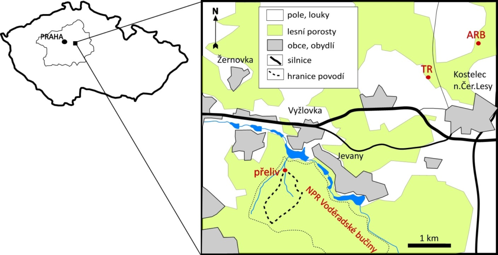
The Lesní potok basin is located in the nature reserve Voděradské bučiny (Voděrady Beechwood) established in 1955 on an area of 6.82 km2. The territory of Voděradské bučiny was not converted into agricultural land because the soil in the area is rocky and relatively shallow. The predominantly deciduous original forests were changed by forestry activities into purely beech forests with almost no fir trees. The territory of the LES basin covers an area of 0.76 km2, the closure profile with a weir is 406 metres above sea level, the highest point of the catchment area is 505 metres above sea level. The average annual temperature is between 7.6 to 9.2 °C. Ninety-nine percent of the total catchment area is woodland, 46% of the woodland constitute coniferous trees (mostly spruce), 53% are deciduous trees (mostly beech, some hornbeam, birch, and oak). In the river basin there is a Thompson spillway that continually records the water outflow. There used to be a mechanical limnigraph measuring the water outflow (flow rate) in which the record sheets had to be changed weekly. In 2003 the mechanical device was replaced by a digital limnigraph made by OTT HydroMet which records the outflow electronically.
Barbora Dudíková Schulmannová, Vojtěch Janoušek, Tomáš Navrátil, Václav Rybařík and Pavel Vlašímský